Animations
Tsunami Detection and Warning

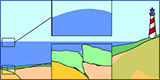
Hazard mapping programs are generated for disaster preparedness. Scientists launch computer-simulated tsunamis at a digital representation of coastlines. This enables them to predict when the tsunami waves will hit the coast, how high they will be, and how far inland they will reach. The maps are used by local officials to plan evacuation routes and make zoning decisions.
Tsunami Generation Animation
Earthquakes that generate tsunamis most often happen where Earth’s tectonic plates converge, and the heavier plate dips beneath the lighter one. Part of the seafloor snaps upward as the tension is released. The entire column of seawater is pushed toward the surface, creating an enormous bulge. As the water flattens out, giant ripples race outward.
Tsunami & Earthquake Research at the USGS

Simulations from various tsunami events are given on this web page.